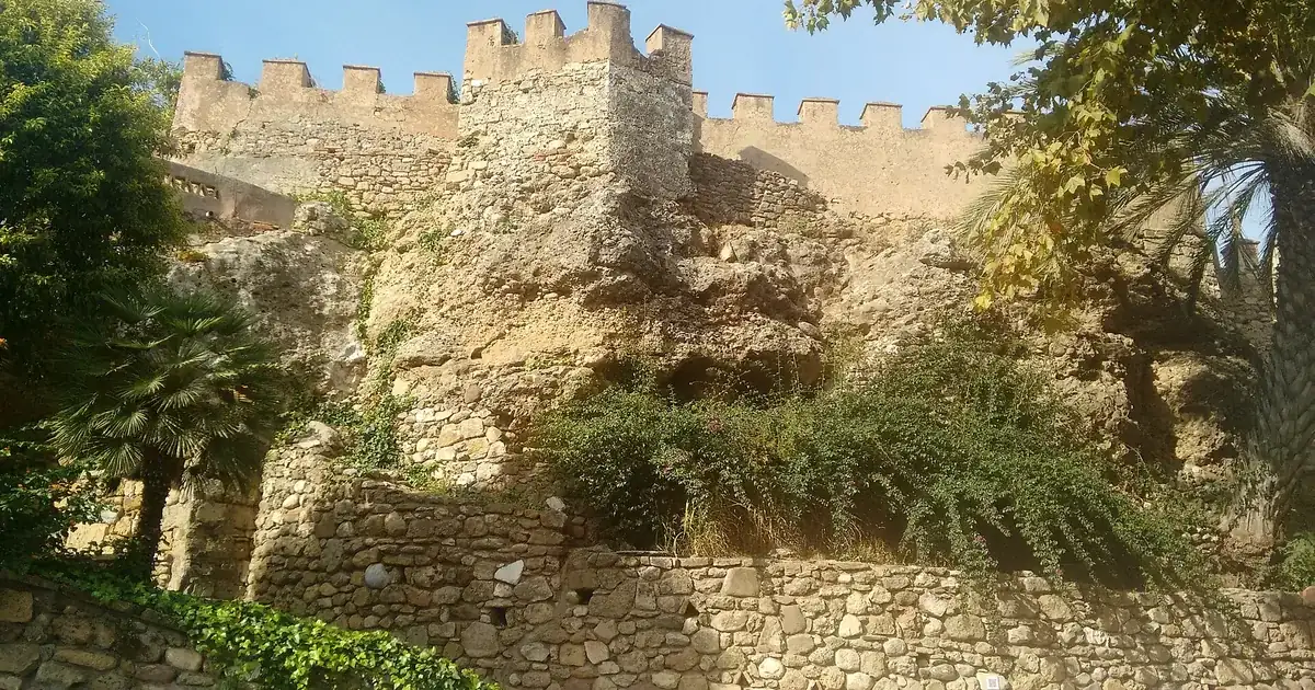
- Marbella's castle is a Caliphal citadel of about 10,650 m² from the time of Abd al-Rahman III, with walls of the 11th and 12th centuries and ten or eleven towers
- You cannot go inside: houses have filled the enclosure for centuries, so the castle is a walk round its outer walls on Calle Carmen, Trinidad, Arte, Portada and Solano
- The wider town wall ran for about 1,045 m with three gates; the best trace today is on Calle Remedios, where the houses use the wall as their façade
- The Barrio Alto grew north of the Puerta de Ronda in the first half of the 16th century around three streets, Calle Ancha, Calle Lobatas and Calle Aduar
- The whole walk takes about 75 minutes; the old town is inside Marbella municipality, so a booking here starts at one hour, €300
On Calle Trinidad there is a stretch of wall where Roman column capitals sit in the masonry like stones that happened to be the right size. The Moors who built Marbella's castle took them from a Roman site nobody has yet found, and most people walk past without looking up. For clients who book escorts in Marbella for an evening in the old town, this is the part of the centre that the usual square-and-tapas route misses; the practical side of booking is in our Marbella escorts guide. The Barrio Alto is the 16th-century quarter north of Marbella's old walled town, and the Moorish castle is the 10th-century citadel at its edge: you cannot enter the castle, but you can walk its outer walls and the Barrio Alto's three main streets in about 75 minutes.
What Is Left of Marbella's Moorish Castle?
Marbella's castle, or alcazaba, is a rectangular citadel built under the Caliphate of Córdoba in the 10th century, in the north-east of the old town. Its walls date from the 11th and 12th centuries and carried ten, possibly eleven, towers. Large sections and several towers survive, but houses fill the inside, so it is seen from the street. It is a protected monument, registered in 1985.
Abd al-Rahman III's Fortress and the 1485 Surrender
The castle is usually dated to the reign of Abd al-Rahman III, who needed a coastal base against the rebel Ibn Hafsun. Archaeologists working on the south wall in 1998 identified the Caliphal bond: big limestone blocks laid alternately lengthwise and endwise, the method used at Madinat al-Zahra outside Córdoba. In the 16th century the Christians adapted the defences for artillery and added a barbican, a word that survives in the name of Calle Barbacana. Marbella surrendered without a fight on 11 June 1485, the feast of San Bernabé, which is why the saint became the town's patron and why the San Bernabé feria peaks every 11 June.
Why You Cannot Go Inside
Once the fortress lost its military role, houses moved in and never left; a 2019 Junta de Andalucía report says that use continues today. In the 19th century, and possibly from the mid-18th, part of the enclosure served as the town cemetery. A restoration plan was drawn up in 1735 and the south wall was restored in 1998, and in 2019 surveyors laser-scanned the north and north-east walls in 40 passes for a consolidation project. The castle has been a Bien de Interés Cultural since 1985, according to its Spanish Wikipedia entry. There are no tickets and no opening hours, which suits an evening walk.
Walking the Castle Walls, Street by Street
The castle's outline follows eight streets: Solano, Portada, Arte, Salinas, Trinidad, Carmen, Ortiz del Molinillo and Virgen de los Dolores. Start at the Plaza de la Iglesia, walk east along Calle Carmen and Calle Trinidad, turn north up Calle Arte and come back west along Calle Portada and Calle Solano. The circuit is well under a kilometre. Allow 25 minutes with stops.
The Towers and Where to Stand
| Tower | Where | What to look for |
|---|---|---|
| Torre Blanca | Plaza de la Iglesia, corner of Calle Carmen | The tower beside the Encarnación church |
| Torre del Reloj | Calle Carmen | The tower the usual old-town route walks past |
| South wall | Calle Trinidad | Reused Roman Ionic capitals in the masonry |
| Torre del Cubo (Santa María) | Calle Portada at Calle Arte | A curved front added to a square tower |
| Torre del Homenaje (Chorrón) | Halfway along Calle Portada | The keep |
| Torre de la Campana (Puente Levadizo) | Portada, Solano and Escuela | The north-west corner; its other name means drawbridge |
The names come from the council's heritage pages and date from after 1485. Houses lean against several towers, so expect a face or a corner, not the full height.
Calle Trinidad, the Roman Capitals and Plaza de San Bernabé
Calle Trinidad runs along the south wall, the stretch restored in 1998, and it is where the Roman capitals are set into the face. Nobody knows which Roman building they came from; their reuse is the main evidence for a Roman settlement on this hill. Steps lead up from Calle Carmen to the Plaza de San Bernabé, which opens inside the castle's southern enclosure, and Calle Castillo and Calle Barbacana carry on towards Calle Portada. In our experience the walls read best in the last hour of daylight, when the low sun picks out the stone; on 22 October that means starting around 18:45.
Calle Portada After Dark
Calle Portada, along the north side, has the keep and the curved Torre del Cubo, and far fewer people than the streets round the Plaza de los Naranjos. The cobbles are worn smooth. The wider old-town loop, with the church, the hospitals and the square, is in our old town walking route; this walk deliberately stays on the castle and the quarter above it. Keep your voice down after 23:00, because people live in these houses.
The Town Wall: Three Gates and Houses Built Into It
A second wall, the cerca, enclosed the Moorish town below the castle. A published survey puts the walled town at about 61,250 m² including the castle; the town wall itself, not counting the castle, ran for roughly 1,045 m and had three gates: the sea gate, the Málaga gate and the Ronda gate. Most of it now hides inside later houses. Two rivers, the Huelo and the Arroyo de la Represa, served as its moats.
Calle Remedios, Where the Wall Became the Façade
The clearest trace is on Calle Remedios, just off the castle's north-west corner, where the houses were built against the wall and simply cut doors and windows into it. A 2016 dig at number 6 confirmed a small tower with a rounded end, visible to about 9.5 metres on the Remedios side, and the wall running from it at about 1.1 metres thick. A longer run of rammed-earth wall, around ten metres with a narrow sentry walk, survives in a private patio on Calle Caballeros; from Calle Peral you can see its top above number 5. The figures come from Daniel Moreno Fernández's survey of the walls in the journal Cilniana.
Puerta de Ronda, Puerta de Málaga and the Sea Gate
None of the gates survives, but all three left their names on the map. The Ronda gate stood in what is now the Plaza del Puente de Ronda, where travellers from inland came in; Pascual Madoz wrote in 1848 that the wall there had been cut to let Calle Ancha through. The Málaga gate was at today's Plaza del Puente de Málaga, with a bridge over the Represa. The sea gate opened near the Plaza José Palomo and Calle Enrique del Castillo, over a bridge across the Huelo. Stand in the Plaza del Puente de Ronda and you are on the line where the walled town ended and the Barrio Alto began.
How Did the Barrio Alto Grow Outside the Walls?
After the Christian conquest the population grew, and in the first half of the 16th century Marbella spilled out of the Ronda gate northwards, the side safest from Barbary raids. It had wide streets, a main street ending at a church square and a Franciscan convent, which gave it its other name, Barrio de San Francisco. The convent has since disappeared.
Aduares, a Convent and Three Streets
Before the expansion, a few humble settlements called aduares stood near the Ronda gate, and Calle Aduar keeps the word. Around them the planners laid three north-south streets linked by short lanes: Calle Ancha in the middle, Calle Lobatas to the east and Calle Aduar to the west, with the old courtyards known as the corrales altos and bajos off Aduar. Our guide to Holy Week in Marbella shows the processions still using exactly these lines. The quarter's grand era came later: the council classes Calle Ancha among the town's noble streets of the 19th century, the road to the farmsteads and sugar and olive mills to the north.
What the Diggers Found Under La Fonda
The ground is older than the street plan. When La Fonda, on the Plaza del Santo Cristo, was rebuilt, archaeologists excavated an early modern cemetery belonging to the vanished Ermita de San Sebastián, and below it medieval levels that may belong to a Moorish suburb. Next door at Calle Ancha 27, a 2022 survey reported by the Junta de Andalucía found the date 1754 painted on the threshold, although the land registry lists the house as built in 1925. Planning rules treat the Barrio Alto as a protected zone, so building work here starts with an archaeologist.
Calle Ancha, Lobatas and Aduar: Reading the Street Names
Calle Ancha simply means wide street, and locals called it that because it was wide next to the lanes inside the walls. Calle Lobatas takes its name from 16th-century houses owned by the heirs of one Diego Lobato. Calle Aduar remembers the first settlements outside the gate, and Calle Peral, oddly, honours the submarine pioneer Isaac Peral. None takes more than five minutes to walk.
Calle Ancha, Whatever the Council Called It
Officially the street has had other names: for years it was General López Domínguez, and from 1937 Germán Porras Sainz, according to a local history published by the Asociación Marbella Activa. Nobody used either. It climbs about 280 metres from the Plaza del Puente de Ronda to the Plaza del Santo Cristo, past houses with coats of arms and deep balconies; the Casa Correa at number 18, dated by its heraldry to 1763, is the one to stop for. At the top, the tablao our flamenco guide reviews runs shows into the late evening.
Lobatas, Peral and the Corrales
Calle Lobatas is where the quarter still feels lived in, with geraniums on the balconies and neighbours who know each other by nickname. In the post-war years it had two wood-fired bakeries, and most of the Barrio Alto lived from farm work and the mines. Calle Peral was named for Isaac Peral, the Cartagena naval officer who built an early electric submarine, and the name was shortened by locals who found the full one too long. On the Monday of Holy Week, the Columna brotherhood leaves the Santo Cristo at 20:30 and walks Calle Lobatas over a carpet of petals.
Plaza del Santo Cristo: The Chapel, the Fountain and the Hotels
The square at the top of Calle Ancha holds the Ermita del Santo Cristo de la Vera Cruz, built in the second half of the 16th century as part of the Franciscan convent, a small fountain locals call the chorros del Santo Cristo, and La Fonda Heritage Hotel at numbers 9 and 10. It is the natural place to end the walk.
The Santo Cristo and the Esparto Years
Look for the carved stone doorway with its heraldic stones and, behind the altar, the octagonal camarín with a roof of glazed tiles; inside, a Tuscan column runs down into the font. After the Civil War the parish priest Rodrigo Bocanegra turned the run-down church into a workshop where local women wove esparto grass from Sierra Blanca for a living. Today it is the home of the Vera Cruz brotherhood, which leaves at 23:30 on Holy Thursday and raises its great cross at the chapel door.
La Fonda and Hotel Claude: Sleeping in the Barrio Alto
La Fonda Heritage Hotel occupies three 16th-century buildings on the square, was the first Relais & Châteaux hotel in Andalucía and lists 20 rooms, a restaurant, the Los Patios terraces and a Sky Bar with old-town views; its October and November 2026 programme includes live music. A few minutes away on Calle San Francisco, the street named after the lost convent, Hotel Claude has seven rooms in a 17th-century house. Both are compared, with prices, in our boutique hotels guide.
An Evening in the Barrio Alto With a Marbella Escort
The old town is inside Marbella municipality, so the standard one-hour minimum applies: €300 for an hour, €600 for two. A walk round the walls followed by dinner is a dinner date, three hours or longer from €900. She usually reaches the old town 25 to 30 minutes after we confirm, and you cover her short taxi. Prices are the same in October as in August.
Where We Set the Meeting Point
Cars cannot get into the castle lanes, so we name a spot a taxi can reach: the Alameda fountain, or the Plaza del Puente de Ronda at the foot of Calle Ancha. The mistake we see most is booking dinner first and the walk after, when the walls are in the dark and the restaurant is at the other end of town. Walk at 18:45 (17:45 once the clocks go back on 25 October), sit down at 20:30 near the castle, finish with a drink on the Plaza del Santo Cristo. Clients staying at Hotel El Fuerte can walk up from the seafront in about ten minutes. Our dinner date companions know these streets, and we tell her to wear flat shoes for the cobbles.
The Money, Briefly
She is paid when she arrives, in euros, by bank transfer or in crypto; nothing here runs on a card. Book a few days out and 25% goes ahead by transfer or crypto; book this evening and nothing is due until she arrives. A dinner can be moved free until 24 hours before, an hourly booking until two hours before. If the evening runs on, extra time is settled on the spot. The details are in what a booking costs, how payment works and our cancellation guide.
Frequently Asked Questions
Can you go inside Marbella castle?
No. Houses have occupied the inside of the enclosure for centuries and the castle has no visitor entrance, tickets or opening hours. You see it from outside by walking the streets that follow its walls, mainly Calle Carmen, Calle Trinidad, Calle Arte and Calle Portada, which takes about 25 minutes with stops.
Where is the Barrio Alto in Marbella?
Directly north of the old walled town, starting at the Plaza del Puente de Ronda, where the Ronda gate used to stand. Its spine is Calle Ancha, which climbs about 280 metres to the Plaza del Santo Cristo, with Calle Lobatas to the east and Calle Aduar to the west.
How old are Marbella's castle walls?
The citadel is dated to the 10th century, under the Caliphate of Córdoba, and the council dates the surviving walls to the 11th and 12th centuries. Reused Roman capitals in the south wall point to an older settlement on the site, and the Christians strengthened the defences for artillery in the 16th century.
What is the best time to walk Marbella's castle walls?
The last hour of daylight, when the low sun lights the stone and the streets are still awake. In late October that means starting around 18:45, or about 17:45 once the clocks go back. Avoid midday in summer, and keep noise down after 23:00 because people live in these houses.
Walking the Castle Walls This Week?
Send us the evening, the time of your dinner booking and whether you would rather meet at the Alameda fountain or at the foot of Calle Ancha. We will time her arrival so the walk catches the last of the light and quote the full price, taxi included, on WhatsApp.
Book on WhatsApp